Part 4 of the National Building Code of Canada (NBCC 2020) mandates a rigorous site-specific hazard assessment for critical facilities on Class C through F sites, and in the Lanaudière region, the complex Quaternary stratigraphy makes generic code spectra a risky shortcut. Terrebonne sits atop a buried valley system carved into the Canadian Shield, where soft Champlain Sea clays interfinger with coarse glacial outwash—a depositional environment that routinely produces impedance contrasts capable of amplifying long-period ground motion. Our seismic microzonation service moves beyond the simple Vs30 proxy by deploying multi-method geophysical arrays that resolve the shear-wave velocity profile to depths exceeding 30 metres, directly informing 1D equivalent-linear site response analyses. For deep foundation designs on the Île des Moulins side, where Holocene alluvium overlies till at variable depth, we pair downhole seismic testing with MASW to constrain the velocity model without relying solely on regional correlations, reducing epistemic uncertainty in the design acceleration spectrum.
Site amplification in Terrebonne's Champlain Sea clays can push spectral accelerations well beyond the uniform hazard curve—ignoring the basin resonance is a liability, not a code compliance strategy.
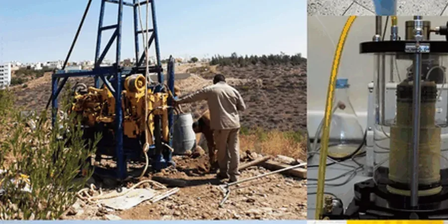
Methodology applied in Terrebonne
Demonstration video
Local geotechnical conditions in Terrebonne
Terrebonne’s urban expansion eastward from the Vieux-Terrebonne core has pushed residential subdivisions and commercial corridors onto compressible soils that were bypassed by earlier construction, and those parcels sit within a moderate seismicity zone controlled by the Western Quebec Seismic Zone. The Charlevoix-Kamouraska source contributes long-period energy that propagates efficiently through the St. Lawrence platform, and when that energy enters the deep clay basin beneath Côte de Terrebonne, the fundamental site period can shift into the 0.5–0.8 second range—coinciding with the natural period of mid-rise concrete frames. A design that relies on the code default Site Class C spectrum for a Site Class E profile underestimates the spectral ordinate at 0.5 s by as much as 40%, based on our own site response runs for local soil columns. The financial exposure is concentrated in the post-earthquake downtime: a structure that survives but cannot be reoccupied because of excessive drift or non-structural damage represents an uninsured business interruption loss that microzonation directly mitigates by providing the structural engineer with a defensible, site-specific design spectrum.
Our services
The microzonation campaign integrates subsurface reconnaissance, geophysical imaging, and geotechnical laboratory testing into a single workflow calibrated for the Lanaudière soil context. Each component addresses a specific source of uncertainty in the site response chain.
Deep Borehole Seismic Array
Installation of triaxial geophones at 1.5 m intervals in mud-rotary boreholes advanced to refusal on till, with SPT energy calibration for each hammer blow. Provides the ground-truth velocity log for surface wave inversion.
Multi-Method Surface Geophysics
Simultaneous acquisition of MASW (passive roadside and active sledgehammer) and P-wave refraction along the same spread, resolving the Poisson ratio variation that distinguishes saturated soft clay from loose sand.
Cyclic Laboratory Testing
Resonant column and cyclic direct simple shear tests on undisturbed Shelby tube samples of Champlain Sea clay, generating modulus reduction and damping curves (G/Gmax and D vs. shear strain) for the specific soil unit.
Probabilistic Liquefaction Hazard Map
CPT-based triggering analysis using the Boulanger & Idriss (2014) procedure, with SPT cross-check in gravelly interbeds. Outputs lateral spreading displacement and post-liquefaction reconsolidation settlement contours for the site.
Questions and answers
What is the difference between a standard seismic site classification and a full microzonation study?
A standard NBCC site classification assigns a single Site Class (A through E) based on an average Vs30 measurement, which then multiplies the uniform hazard spectrum by a code-prescribed amplification factor. A microzonation study replaces those generic factors with a site-specific transfer function derived from 1D wave propagation analysis using the measured shear-wave velocity profile and laboratory dynamic soil properties. It accounts for impedance contrasts at depth that Vs30 smoothing erases, and it produces a design spectrum that can differ substantially in shape—not just amplitude—from the code spectrum, particularly at periods above 0.3 seconds in Terrebonne's basin deposits.
How many boreholes and geophysical lines are needed for a typical Terrebonne commercial development?
For a mid-rise structure on a parcel under one hectare, we typically recommend a minimum of two deep boreholes with downhole seismic arrays and two intersecting MASW/refraction transects, forming a cross that captures the stratigraphic variability in both the north-south (toward the river) and east-west directions. The exact layout depends on the bedrock depth gradient visible on the surficial geology maps; we adjust the grid after reviewing the MERN SIGÉOM database for the specific cadastral lot. A larger industrial facility may require four to six boreholes with a 25-metre line spacing to resolve paleochannel edges.
What is the typical cost range for a seismic microzonation study in the Terrebonne area?
Budget between CA$5,940 and CA$25,850 depending on the number of boreholes, the depth to refusal, the geophone array length, and whether cyclic laboratory testing is required. A small commercial lot with one borehole and a single MASW line falls at the lower end; a multi-structure campus with deep till, multiple transects, and resonant column testing on several Shelby tube samples approaches the upper bound. We provide a fixed-price proposal after reviewing the geotechnical desk study for the specific municipal address.
Can a microzonation study reduce the seismic design loads compared to the NBCC default spectrum?
Yes, in certain stratigraphic conditions. If the velocity profile reveals a stiff till layer at shallow depth that the Vs30 method misclassifies as a softer site, the site-specific spectrum may actually fall below the code default at short periods, allowing a more economical lateral force-resisting system. Conversely, when thick soft clay is present, the site-specific spectrum typically exceeds the code spectrum at longer periods, which is the hazard the study is designed to capture rather than the cost saving. We present both scenarios transparently so the structural engineer can make an informed decision.
How long does a complete microzonation study take from field work to final report?
Field work including drilling, downhole seismic acquisition, and surface geophysics typically requires three to five working days for a standard commercial parcel, assuming reasonable weather and access conditions. Laboratory cyclic testing on undisturbed clay samples adds two to three weeks for consolidation and staged shearing. Data processing, dispersion curve inversion, site response modeling, and report drafting take an additional two weeks. A realistic total timeline from mobilization to the issuance of the signed, engineer-stamped report is four to six weeks, though we can deliver preliminary spectra earlier if the structural design schedule demands it.