Terrebonne sits on the north shore of the Mille Îles River, where the Champlain Sea deposited thick, sensitive clays that still govern how we build today. The National Building Code of Canada (NBCC 2015, Division B, Part 4) requires a rigorous slope stability analysis for any cut deeper than 1.2 meters in these marine sediments, and the city's rapid residential expansion into the old agricultural terraces means we are constantly evaluating natural and engineered slopes. Our team runs limit equilibrium models using Spencer's method and finite element stress paths, feeding in site-specific shear strengths from consolidated-undrained triaxial tests. When a developer proposes a new subdivision off Rue Saint-Louis, the first question is always about the 10-meter terrace edge that overlooks the river plain—and whether it will hold under saturated spring conditions. For deeper investigations of the underlying strata we often pair the analysis with a test pits program to log the oxidized crust thickness, which can add a deceptive 2 to 3 kPa of apparent cohesion that disappears once the crust is breached.
A Champlain Sea clay slope at 26 degrees can stand for decades—until a single spring thaw pushes pore pressure past the tipping point in under 48 hours.
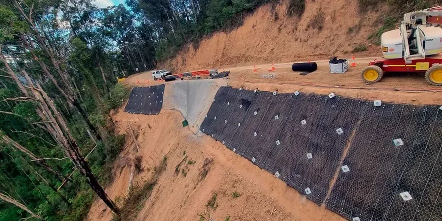
Methodology applied in Terrebonne
Local geotechnical conditions in Terrebonne
With Terrebonne's population now exceeding 119,000 and climbing toward 125,000, development pressure is pushing into areas where the Champlain clay meets the underlying glacial till at uncomfortable angles. The 2010–2019 seismic hazard model for southern Quebec assigns a 2% in 50-year PGA of roughly 0.15g to this region, and while that number looks modest on paper, the real risk is in the clay's sensitivity. Champlain Sea clay in the Terrebonne area can exhibit sensitivity ratios above 15, meaning a small initial failure can cascade into a large retrogressive landslide. The 1971 Saint-Jean-Vianney slide, though farther east, remains the cautionary reference for anyone working in these deposits. In our analyses we explicitly check for strain-softening behavior by inputting both peak and fully-softened strength envelopes, and we flag any slope where the post-peak loss exceeds 40% for further stabilization design. The municipality's own zoning maps identify several sectors along the Mille Îles River as susceptible to landslides, and we coordinate with the Service de l'urbanisme when our analyses indicate a need for setback adjustments or tiered benching.
Our services
Every slope stability analysis in Terrebonne must account for the layered stratigraphy that defines the north shore of the Mille Îles River: a desiccated clay crust over soft intact marine clay, sometimes interrupted by pockets of glaciofluvial sand that act as confined aquifers. Our analytical approach adapts to each stratigraphic scenario and construction objective.
Embankment and cut slope design
We analyze proposed embankment geometries for new subdivisions and municipal infrastructure, optimizing slope angles to achieve NBCC-compliant factors of safety while minimizing earthwork volumes. Our models incorporate staged construction sequencing and consolidation-driven strength gain over time, which often allows steeper final profiles than a single-stage analysis would suggest.
Riverbank and natural slope assessment
For existing slopes along the Mille Îles River and its tributary streams, we conduct forensic stability reviews that account for toe erosion, fluctuating water levels, and the ice-scour effects unique to Quebec's freeze-thaw rivers. These assessments are frequently required for property transactions, insurance due diligence, and municipal permitting near designated landslide-prone zones.
Questions and answers
How much does a slope stability analysis cost for a residential lot in Terrebonne?
For a typical single-family lot slope assessment, fees range from CA$1,820 to CA$4,960 depending on the slope height, access conditions, and whether intrusive investigation (boreholes or test pits) is required prior to the analysis. Projects involving complex stratigraphy or the need for transient seepage modeling fall toward the upper end of that range.
What is the minimum factor of safety required by the NBCC for permanent slopes?
The NBCC 2015 requires a minimum static factor of safety of 1.5 for permanent slopes under long-term drained conditions. For seismic loading, a pseudo-static factor of safety of at least 1.1 is required using the peak ground acceleration specified in the NBCC seismic hazard maps for southern Quebec. Temporary construction cuts can be designed to a lower static factor of 1.3 if the exposure period is short and monitoring is in place.
How does the Champlain clay affect slope stability in Terrebonne?
Champlain Sea clay is a sensitive marine deposit with a metastable flocculated structure. When remolded or subjected to large strains, its undrained shear strength can drop by 60 to 80 percent. This sensitivity means that a small initial failure can trigger a much larger retrogressive slide. Our analyses use both peak and fully-softened strength envelopes to evaluate this risk, and we apply Bjerrum's vane correction to field vane data to avoid overestimating the in-situ strength.
Do you need to account for spring thaw conditions in the analysis?
Yes, and it is one of the most critical loading scenarios we model. During the March-April thaw, meltwater infiltrates the desiccated crust faster than the underlying clay can drain, creating a perched water table and elevated pore pressures. We run transient seepage analyses (SEEP/W) coupled with limit equilibrium (SLOPE/W) to simulate this condition over a 72-hour window, and the resulting factor of safety is often the governing case—lower than both the long-term steady-state and the seismic pseudo-static scenarios.